


Hills Garlic Festival
The 23rd annual Hills Garlic Festival will be held on September 15, 2015, from 10am to 5pm at Centennial Park, New Denver, BC.
Visit SiteWith over fifteen kilometers of well used trails accessible from hotsprings road, the Kuskanax Valley will impress any hiker. Love the feel of being in old growth cedar? Try the Cedar Grove Trail. Enjoy sitting by quiet subalpine lakes? Hit the Kimbol Lake Trail for the day. Want a sweeping vista? Hit the Kuskanax Summit Trail! Then bring it all home to the hotsprings for a relaxing evening. Oh, and don’t forget to check out our award winning footbridge either!
With over fifteen kilometers of well used trails accessible from hotsprings road, the Kuskanax Valley will impress any hiker. Love the feel of being in old growth cedar? Try the Cedar Grove Trail. Enjoy sitting by quiet subalpine lakes? Hit the Kimbol Lake Trail for the day. Want a sweeping vista? Hit the Kuskanax Summit Trail! Then bring it all home to the hotsprings for a relaxing evening. Oh, and don’t forget to check out our award winning footbridge either!
The forest service roads and cross country ski trails in the area are frequented by mountain bikers of all skill levels; however, only the most extreme riders will tackle the climb and descent of Kimbol Lake. One of the most popular rides is the 8.5 km Kuskanax Creek/Hot Springs Trail, which winds through our stunning Cedar and Hemlock forests and arrives at the Kuskanax Creek Bridge just a short jaunt from the Hot Springs.
The forest service roads and cross country ski trails in the area are frequented by mountain bikers of all skill levels; however, only the most extreme riders will tackle the climb and descent of Kimbol Lake. One of the most popular rides is the 8.5 km Kuskanax Creek/Hot Springs Trail, which winds through our stunning Cedar and Hemlock forests and arrives at the Kuskanax Creek Bridge just a short jaunt from the Hot Springs.
Slow down, take a deep breath of pristine mountain air and enjoy all that nature has to offer on our stunning property. Our beautiful, calm, and quiet settings allow for quiet reflection and enjoyment. Whether you wish to meditate, or just take it all in, our trails, woodlands, and the Kuskanax Creek will delight you. A leisurely stroll or just sitting back will allow you to enjoy the sounds of nature in our woods. You’ll be amazed at how relaxed you will be.
Slow down, take a deep breath of pristine mountain air and enjoy all that nature has to offer on our stunning property. Our beautiful, calm, and quiet settings allow for quiet reflection and enjoyment. Whether you wish to meditate, or just take it all in, our trails, woodlands, and the Kuskanax Creek will delight you. A leisurely stroll or just sitting back will allow you to enjoy the sounds of nature in our woods. You’ll be amazed at how relaxed you will be.
Skiing opportunities are close by our Hot Springs. The local Summit Lake Ski Hill is within a half hours drive from the Hot Springs. The Revelstoke Mountain Resort is about two hours and twenty minutes away (120 km, includes a ferry). The Whitewater Ski Resort by Nelson is about two and a half hours away (160 km).
Skiing opportunities are close by our Hot Springs. The local Summit Lake Ski Hill is within a half hours drive from the Hot Springs. The Revelstoke Mountain Resort is about two hours and twenty minutes away (120 km, includes a ferry). The Whitewater Ski Resort by Nelson is about two and a half hours away (160 km).
If you like to hit the backcountry in winter, you need to come here. Not only do you have our trail network to explore, you also have an entire valley to check out, with virtually limitless opportunity for adventure. Bring your skins. If you enjoy a nice set track, check out the Wensley Creek Ski Area in Nakusp!
If you like to hit the backcountry in winter, you need to come here. Not only do you have our trail network to explore, you also have an entire valley to check out, with virtually limitless opportunity for adventure. Bring your skins. If you enjoy a nice set track, check out the Wensley Creek Ski Area in Nakusp!
Snow abounds here and our warm winter conditions are perfect for memorable snowshoeing experiences. Many of our local trails are suitable for snowshoeing with the Kuskanax Creek/Hot Springs Trail being a favourite.
Snow abounds here and our warm winter conditions are perfect for memorable snowshoeing experiences. Many of our local trails are suitable for snowshoeing with the Kuskanax Creek/Hot Springs Trail being a favourite.
We get a lot of winter warriors up at the hotsprings, and sledders are no exception. There are numerous locations for sledding within short driving distances. Forest service roads run all the up the valley, as far as the Tenderfoot Glacier. Come and check out the backcountry! We get lots of snow…..lots.
We get a lot of winter warriors up at the hotsprings, and sledders are no exception. There are numerous locations for sledding within short driving distances. Forest service roads run all the up the valley, as far as the Tenderfoot Glacier. Come and check out the backcountry! We get lots of snow…..lots.
Cedar Grove Trail is a gentle half kilometre loop through a stand of majestic old growth Western Red Cedar trees. Hikers of all abilities can access superb interior rainforest habitat, untarnished by natural or industrial disturbances. The trees in the grove, some with a diameter of over 2 metres, are hundreds of years old. They tower over 30 metres high, affording a canopy of dense green cedar bows, home to many species of birds and insects, as well as lichens, mosses and plants that feed larger mammals. The Devil’s club, lady fern and cedar trees in the grove are typical of a moist interior forest site. This particular old growth habitat hosts the lichens and shrubs upon which southern mountain caribou feed during their late fall and early spring low elevation migration.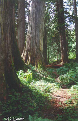
To access Cedar Grove Trail, drive north from Nakusp on Highway 23, toward Revelstoke. About 2 km from town, turn right onto Hot Springs Road, and follow the road for 10.8 kilometres. Turn left onto the Kuskanax Forest Service Road (GPS Point 1 on the map); drive for 4.2 km and look for the “Cedar Grove Trail .8 km” sign (GPS Point 2). Veer left at this sign and follow the road for 1 km; here the road branches onto a spur road. Go straight on the spur; don’t take the uphill turn. A yellow sign at this branch says “.3km to trail” (GPS Point 3). A few hundred metres along this branch there is a wide area to turn around and park a vehicle (GPS P ), and the trail head sign marks the beginning of the loop 100 metres further along (GPS Point 4).
Cedar Grove Trail is a relatively flat trail of compact dirt. The walk around the loop is a nice, easy stroll for almost anyone. Although the trail isn’t accessible to wheelchairs, bikes or strollers, one could wheel up to the trail head and enjoy the surroundings from there.
The Cedar Grove trail was built by the Ministry of Forests in this special forest reserve to maintain and share the habitat in its natural state.
If the Cedar Grove Trail appealed to you, try Wrap Around Nakusp, Box Lake Loop or portions of Rosebery Railway Trail, which are also relatively short, easy hikes in this area.
The Trails of Nakusp brochure series was produced for the Gentle trail through cedar giants Nakusp & District
Chamber of Commerce, by Hailstorm Ridge Environmental Services & Kootenay Virtual Tours, who jointly retain copyright.
Project funding came from a 2003 Columbia Basin Trust Community Initiatives Grant.
Many thanks to True North Forestry Consulting Ltd., Pope & Talbot Ltd., Slocan Forest Products and the Ministry of Forests for their various contributions to the project.
www.nakusphotsprings.com
www.for.gov.bc.ca www.bcrockies.com
www.hellobc.com/bcescapes/regions/bcrockies.asp
www.gov.bc.ca/bcparks/recreation.htm
∗ All brochures in the Trails of Nakusp series are available online at: www.nakusparrowlakes.com
The Kimbol Lake Trail provides a great low elevation hike in spring, summer or fall. The 4 kilometre trail winds through imposing cedar and hemlock forests along the southern slope of the Kuskanax Creek valley, at first, and then climbs into the narrower Kimbol Lake valley. The first leg of the journey follows the .8 km trail to the Hotsprings’ source (GPS Point 1 on the map), the site of the original hotsprings resort. Cement forms remain where once sat the pools to which tourist trekked by packhorse from the paddlewheelers docked in Nakusp. Poison ivy, uncharacteristic in the area, thrives on the open ground at the source.
In the far southeast corner of the clearing, a brown wooden sign marks the beginning of the Kimbol Lake Trail. Immediately the trail begins a steep climb, but levels out 50 metres later to amble through stately stands of cedar and hemlock, with a rich undergrowth of Devil’s club, huckleberries and ferns (GPS Point 2). As the trail winds deeper up the Kuskanax River valley, the cedar/hemlock forest remains uniform, with abundant underbrush where logging or blow-down enables more sunlight to penetrate the canopy of trees.
The trail grade is slight at first, but, as the trail dips down to cross numerous creeks and draws, there are steep pitches; a 40% grade is the steepest. About half way there, the trail crosses an old logging road (GPS Point 3), which provides a view of the old growth “Cedar Grove” across the valley. The trail then climbs steadily up and around the mountainside (GPS Point 4), as it enters the small Kimbol Lake valley, where it again levels off. A watchful eye on the steep trail sections will help avoid their exposed tree roots and loose rocks.
Cresting the hill and entering the Kimbol Lake valley, the relationship between geography and biology is profound, as here the flatter, moister land hosts magnificent trees and a rich undergrowth layer (GPS Point 5). Devil’s club thrives due to the underground drainage from Kimbol Lake; rhododendron and huckleberries are abundant too. Excellent habitat for bears and other large mammals results from the plentiful berries and roots, ample drinking water and prime den sites amongst tree roots and the rockslide boulders.
The trail winds toward Kimbol Lake for the last half kilometre, accessing its western shore from the rocky talus slope (GPS Point 6). Here, some time for a rest, lunch or casting for small rainbow trout or mountain whitefish is in order. A walk around the lake will reveal an old trapper’s cabin at the southeastern end of the lake. Wilson Lake Road previously provided road access to the cabin but is now washed out. After enjoying the scenery, the quick walk back to the Hotsprings leads to a relaxing and well-deserved soak.

To access Kimbol Lake Trail, drive north from Nakusp on Highway 23, toward Revelstoke. About 2 km from town, turn right onto Hot Springs Road, and follow the road for 12 kilometres to the Nakusp Hotsprings. Park here, and follow the wide trail leading from the northeastern end of the parking lot (GPS P ); the trail crosses the suspension bridge over Kuskanax Creek and forks a hundred metres further along. Take the left fork, which leads to the hotsprings source and the brown wooden Kimbol Lake trail marker.
Because of its steep pitches (up to 40%) and occasional muddy patches, Kimbol Lake trail is primarily traveled on foot. The trail is in good shape, and biking it is possible for the more extreme enthusiast.
The Kimbol Lake trail was established by the Ministry of Forests as a recreation trail. The lake was stocked periodically with Rainbow trout until 1987. The cabin at the far end of the lake attests to the lake and surrounding area’s historical use for hunting and trapping.
For more spring and fall hiking and biking, try Nakusp Hotsprings trail, Wensley Creek or portions of Rosebery Railway Trail. Nearby as- cents include Kuskanax Mountain and Saddle Mountain Lookout trails.
The Trails of Nakusp brochure series was produced for the Gentle trail through cedar giants Nakusp & District
Chamber of Commerce, by Hailstorm Ridge Environmental Services & Kootenay Virtual Tours, who jointly retain copyright.
Project funding came from a 2003 Columbia Basin Trust Community Initiatives Grant.
Many thanks to True North Forestry Consulting Ltd., Pope & Talbot Ltd., Slocan Forest Products and the Ministry of Forests for their various contributions to the project.
www.nakusphotsprings.com
www.for.gov.bc.ca www.bcrockies.com
www.hellobc.com/bcescapes/regions/bcrockies.asp
www.gov.bc.ca/bcparks/recreation.htm
∗ All brochures in the Trails of Nakusp series are available online at: www.nakusparrowlakes.com
Vicky’s View is an accessible and spectacular viewpoint close to town. You can reach Vicky’s View via the Kuskanax Mountain Road. A short walk through the forest takes you to awesome views of Upper Arrow Lake, the village of Nakusp, the Valhalla Range to the south and the Monashee Range to the west.
From the 4-way stoplight in downtown Nakusp, drive north on Hwy 23 for 2.5 km. Turn right on to the Hot Springs Road. Drive 3.6 km up the Hot Springs Road. Turn left onto the Kuskanax Mountain Road (gravel). Then, drive (or hike) 1.5 km up the Kuskanax Mountain Road and you will find Vicky’s View on your left. A high clearance all- wheel drive vehicle is recommended for Kuskanax Mountain Road. Please park in the nearby pullout so that other vehicles can pass by.
From the 4-way stoplight in downtown Nakusp, drive north on Hwy 23 for 11.5 km. Turn right onto Turner Road (gravel). Follow the wooden “TRAIL” signs for 15 km (50 minutes) to the end of the road. In a large clear-cut at the end of the road you will find the signed parking area/trailhead.
From the 4-way stoplight in downtown Nakusp, drive north on Hwy 23 for 2.5 km. Turn right onto the Hot Springs Road. Drive 3.6 km up the Hot Springs Road. Turn left onto the Kuskanax Mountain Road (gravel). Drive for 4.2 km to the signed parking area/trailhead. Watch closely for the trail signs – just above the parking area, the trail takes a sharp left off of the old road.
The Kuskanax Mountain Trail can be made into a loop route by leaving a vehicle at one trailhead and starting your hike at the other trailhead.
* Challenging hike, 6.1 km
** Hiking time: 5-7 hours, one trailhead to the other
Follow safe hiking practices and be sure to tell someone where you are going and when you expect to return. Take drinking water.
Nakusp and Area Community Trails Society
www.nakusphotsprings.com
www.for.gov.bc.ca www.bcrockies.com
www.hellobc.com/bcescapes/regions/bcrockies.asp
www.gov.bc.ca/bcparks/recreation.htm
∗ All brochures in the Trails of Nakusp series are available online at: www.nakusparrowlakes.com

This all-season trail provides great spring, summer and fall hiking, biking and horseback riding and some winter snowshoeing. The trail meanders along the side slope above the Kuskanax Creek from just outside Nakusp up the valley to the Nakusp Hotsprings, following the pioneers’ original packhorse route of 1912.
The first three or four kms wander through lofty cedar and hemlock stands, which thrive in the ideal moist habitat created by rain from eastbound clouds crossing the Selkirk Mountains. Under the towering canopy exists a diverse undergrowth of mosses, Western yew, Devil’s club, huckleberry, oak fern, lady fern, maidenhair fern and smaller wild ginger, sarsaparilla, fairy slipper, Queen’s cup and wintergreen. Remnants of burnt out tree stumps stand like sentinel ghosts from times past, providing evidence of the natural fires that used to regularly sweep through BC’s interior valleys. Recent logging near the beginning of the trail attempted to minimize the impact of the small clear-cut harvest to the trail’s integrity.
An hour’s hiking leads to the bluffs, laden with maidenhair ferns and ginger, where views extend to the creek far below and to the lake (GPS point 2 on the map). Continuing on through the forest, log bridges cross the many small creeks. Upon approaching the next rest stop (GPS point 3), decadent hemlock, fir and cedar tower nearly 40 metres above, shading the forest floor and creating a magnificent, mossy bowl. The benches, outhouse and hitching post built long ago by pioneers have been recreated, so hikers can enjoy the enchanting rest spot. Marshy ground is criss-crossed with boardwalks; hanging moss gardens dangle from elevated tree branches, and overgrown trail-blazes display more evidence of the trail’s history.
Further up the valley, a keen eye will spot the Nakusp Hotsprings across Kuskanax Creek (GPS Point 4). After passing a rundown cabin and corral, the trail branches to the hotsprings source (.8 kms) and the Kimbol Lake trail (GPS Point 5). For a therapeutic soak, cross the suspension bridge over Kuskanax Creek, and follow the path to the Nakusp Hotsprings.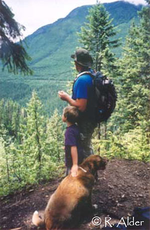
From Nakusp, head south on Highway 6 toward Nelson for 2 km. Turn left onto Alexander Road at Carson’s Corner Store, drive for 2.3 kms to the brown wooden Kuskanax Ck. Tr sign on the right. Follow the logging road for 1.4 km to a fork, veer right and bump along until the next fork, then head to the left. After the first 1.4 km, the road is quite overgrown and rough, park at the fork if you are wary of your paint or suspension. From the parking area (GPS P ), follow the path through the logged area to the trailhead (GPS Point 1). For convenience, shuttle a second vehicle to the Nakusp Hotsprings before you begin hiking or arrange to be picked up about 4 hours after you begin hiking.
Hikers—With a slight elevation gain, few steep pitches and a well built trail, this hike is ideal for all ages and abilities. Be sure to prepare youngsters or inexperienced hikers for a long walk. Bikers & horseback riders—steep side-slopes and narrow trails can be challenging for bikers and riders; trail riding is rated moderate to difficult. Locals enjoy the fun downhill ride from the hotsprings to town. Snowshoes—As trail access is poor in winter, begin and end snowshoeing excursions at the hotsprings.
In the 30s and 40s, pack horse caravans met tourists at the docks in Nakusp and spirited them away to soak in the hotspring’s famous mineral waters. This trail follows their route as far as the turn off to the source, where the original hotsprings getaway was situated. In 1998, the Nakusp Chamber of Commerce hired a youth work crew to upgrade the trail and create an interpretive brochure, now available at the Chamber’s Info Centre or the Nakusp Hotsprings.
Other shoulder season day hikes are Kuskanax Mountain, Kimbol Lake and parts of Rosebery Railbed.
The Trails of Nakusp brochure series was produced for the Gentle trail through cedar giants Nakusp & District
Chamber of Commerce, by Hailstorm Ridge Environmental Services & Kootenay Virtual Tours, who jointly retain copyright.
Project funding came from a 2003 Columbia Basin Trust Community Initiatives Grant.
Many thanks to True North Forestry Consulting Ltd., Pope & Talbot Ltd., Slocan Forest Products and the Ministry of Forests for their various contributions to the project.
www.nakusphotsprings.com
www.for.gov.bc.ca www.bcrockies.com
www.hellobc.com/bcescapes/regions/bcrockies.asp
www.gov.bc.ca/bcparks/recreation.htm
∗ All brochures in the Trails of Nakusp series are available online at: www.nakusparrowlakes.com

Just outside of Nakusp lie the Wensley Creek Cross Country Ski Trails, 9.6 kilometres of groomed classic track skiing for both beginner and intermediate skiers in the winter, available for horseback riding, hiking, mountain or dirtbiking in the spring, summer and fall.
The trail is usually ready for skiing by mid-late December, and the season extends through to late March, with variable conditions through- out the season and even along different sections of the trail. Bringing a variety of waxes is recommended.
The trail forms a figure eight, providing two loops of varied terrain for low elevation skiing, hiking, riding or biking. The trails traverse through second growth cedar-hemlock forests, incorporating existing skidtrails and old logging roads. Branching onto Ptarmigan Loop (GPS Point 1 on the map) provides a quick ski on mostly intermediate terrain. The trail passes an old hunter’s cabin on the first hairpin corner, then skirts around behind a hill to pass through the marshy Hasrap Creek corridor. This shady haven for birds and mammals far from the sounds and sights of civilization is a magical part of the trails (GPS Point 5). The section of Ptarmigan Loop from GPS Point 1 to GPS Point 2 is beginner terrain.
Whiskey Jack Trail meets the Ptarmigan Loop in the middle of the figure 8 (GPS Point 2). There is a First Aid survival kit at the junction. Whiskey Jack provides more intermediate skiing terrain. Whiskey Jack Trail also skirts a knobby hill, passing behind and then climbing up to higher ground that provides views of the valley below (GPS Point 4). Here, Taddy Cabin, a newly constructed warming hut, offers shelter for a lunch break, with a stove for warmth and pit toilets nearby (GPS Point 3). Another First Aid survival kit is located at the cabin. From the cabin, beginner terrain leads back to the parking lot.
Taddy Cabin was named after Weldon Taddy, one of the founding members of the Arrow Lakes Cross Country Ski Club. The club’s volun- teers maintain the trails and cabin in the winter, ensuring track is set and wood is available. The 2004 ALCCSC President was Frances Swan (265-4818). A $2 charge for day use is payable at the trailhead for those who are not members of the ski club. The club hosts special events at the trails occasionally, like full-moon skis and Sunday club skis; notices are posted at the trailhead.
Spring, summer and fall use by hikers, horseback riders, mountain and dirt bikers is popular, although by no means crowded.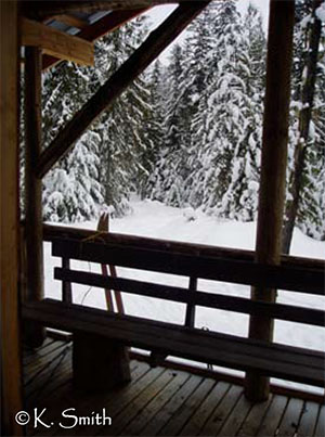
Head south from Nakusp on Highway 6 toward Nelson for about 4 kilometres, past the Nakusp Centen- nial Golf Course. Turn left on Upper Brouse Road and follow it to the top through a series of turns until reaching the parking area for the trails (GPS Point P ).
The trails are designed for skiing and maintained by dedicated skiers, so in the winter other uses, which may destroy the set tracks, are discouraged. Spring, summer and fall useage by other modes provides pleasant diversion for bikers, riders and hikers close to town. No overnight use of the cabin is permitted. The trails are in an important domestic watershed and require due caution.
The Wensley Creek Trails were developed as a Ministry of Forests recreation site in 1982. The Arrow Lakes Cross Country Ski Club has a cooperative agreement with the MOF to maintain and improve the trails. In the past, logging companies working in the area made their cutting plans to accommodate the ski club’s plans, helping to open up new terrain and maintain appropriate grades.
If you enjoyed skiing Wensley Creek, look for cross country tracks behind Summit Lake and between Summit Lake and Hills, described on the Nakusp to Rosebery Railway brochure. Tracks are also set sometimes from the Nakusp Hotsprings; inquire at the desk for more information. If you enjoyed biking or hiking the trail, try the Rosebery Railbed, Nakusp Hotsprings Trail, or the Kimbol Lake Trail.
The Trails of Nakusp brochure series was produced for the Gentle trail through cedar giants Nakusp & District
Chamber of Commerce, by Hailstorm Ridge Environmental Services & Kootenay Virtual Tours, who jointly retain copyright.
Project funding came from a 2003 Columbia Basin Trust Community Initiatives Grant.
Many thanks to True North Forestry Consulting Ltd., Pope & Talbot Ltd., Slocan Forest Products and the Ministry of Forests for their various contributions to the project.
www.nakusphotsprings.com
www.for.gov.bc.ca www.bcrockies.com
www.hellobc.com/bcescapes/regions/bcrockies.asp
www.gov.bc.ca/bcparks/recreation.htm
∗ All brochures in the Trails of Nakusp series are available online at: www.nakusparrowlakes.com
The 23rd annual Hills Garlic Festival will be held on September 15, 2015, from 10am to 5pm at Centennial Park, New Denver, BC.
Visit SiteEvery Wednesday evening in July and August come and experience our local artists performing at the Music in the Park event happening at the Nakusp Municipal Park Gazebo.
Various businesses participate in a self guided tour of local art from May 1st until April 30th. Maps of the tour are available at our Visitor Centre ands at participating locations.
Check out our beautiful Public Beach and our Waterfront Walk which features a stunning floral and horticultural displays and a Japanese Garden.
Nakusp has a weekly Farmer’s Market every Saturday from mid-May through mid-October in downtown Nakusp. Come and browse the wares of local Artisans, shop for fresh local produce, baked goods, and other foods.
The Nakusp Centennial Golf Club offers a challenging and relaxing golfing experience. Nestled in the Arrow Lakes Region, this 9 hole course delivers incredible scenery at great value. Come experience the true Kootenays and friendly small town hospitality.
Visit SiteThe Nakusp & District Museum is home to over 5,500 artifacts from early life on the Arrow Lakes. Our region is rich in the history of sternwheelers on the Arrow Lakes and in agriculture, mining, and logging. The Museum is open in May and September from 11:00 am to 3:00 pm and during June, July, and August from 9:30 am to 5:00 pm.
Visit SiteSince 2007, RMR has offered the most vertical in North America at 1,713 metres (5,620 ft) of lift-accessed terrain, 3,121 acres of fall line skiing, 2 high alpine bowls, and 65 named runs, including legendary glades and phenomenal groomers.
Visit SiteOur local Ski Hill offers an affordable skiing & boarding experience for the whole family. The Summit Lake Ski Hill has been operating under the Nakusp Ski Club Association (N.S.C.A.) for 49 years and is a small, community-based ski hill run through the efforts of dedicated local volunteers.
Visit SiteLocated just outside Nelson BC, on BC’s famous Powder Highway, Whitewater Ski Resort is renowned for receiving over 12 metres / 40 feet of light, dry, powder snow every season. The best thing about the big snow fall, is you don’t have to make room for big crowds common to other BC ski resorts.
Visit Site